Navigation in a survival craft is not precise. First, the survival raft is designed to stay afloat rather than sail. You are not, however, completely at the mercy of the elements, since you can influence, to some degree, the effect of wind and current on your raft .
Knowledge of your position can help you make decisions concerning choice and plan of action. Your position, once known, can aid you in finding the distance and direction to land, to a shipping lane, or perhaps to an area of greater rainfall. Determining your position can also help you make decisions concerning rations and may also favor ably influence mental attitudes, if for no other reason than simply giving you something to do to improve your situation.
POSITION PLOTTING PROCEDURE
If you are lucky you had the time and presence to grab your sextant and tables and bring them along in the raft. If not, or if you don’t know how to work the sextant, the following tables and simple procedures will allow you to ascertain a position within ½ degree (30 nautical miles) and which, if plotted daily, will show you your progress and direction.
One added advantage of the following method of celestial navigation is that you are not dependent upon an assumed position, nor must you plot azimuths or distances. You have, in effect, reduced your chances for error.
To plot your position, you must first determine your latitude and longitude.
Latitude is the measurement, in degrees, of the distance north and south of the equator. New York is approximately 40 degrees north in latitude. Sydney Australia’s latitude is about 34 degrees south.
Longitude is the measurement, in degrees, that you are east or west of Greenwich, England. (A reference point represented by an imaginary vertical line bisecting Greenwich, England). Los Angeles’ longitude is about 120 degrees west. Paris is about 2 degrees east.
Once you establish these approximate values by using the following method you can plot a daily position and course on a chart and determine the distance and direction you have traveled.
DETERMINING YOUR LATITUDE
When you know the day’s date and are able to calculate the length of the day within one minute, you will be able to determine your latitude. (Providing you are at a latitude between 60 degrees north and 60 degrees south. Another exception is between the days of March 11 and 13 and from September 13 through October 2, at which periods the day’s length is almost exactly the same at all latitudes.)
• With your watch, time the exact length of the day from the moment the sun first appears on the horizon (east) to the exact instant it disappears on the western horizon. This means the instant the top of the sun first appears on the horizon to the exact instant the top of the sun disappears below the horizon. (Sometimes marked by a green flash caused by atmospheric refraction.)
• Follow the instructions on the nomogram (Fig. 6-1) for calculating your latitude.
DETERMINING YOUR LONGITUDE FROM APPARENT NOON
• To find your longitude you need to know the rate at which your watch gains or loses time and the time that you last set your watch.
Example:
Your watch gains 1 minute per day.
You last set your watch 4 days ago.
Your watch indicates 12:28 a.m.
12:28
minus 4
equals = 12:24
Corrected or “real” time is 12:24.
• Convert to military time: Convert time to 24 hour periods. i.e., 11:00 a.m. is 1100; 1:00 p.m. is 1300; 10:00 p.m. is 2200, and so on.
• Determine apparent local noon: Simply divide the total hours and minutes of the day by 2. Noon is exactly half way between sunrise and sunset.
• Convert local noon to Greenwich time. To do this refer to the World Time Zone (Fig. 6-2). Find the appropriate time zone and correct your local apparent noon time by adding or subtracting the indicated hours on the bottom of the table. For example: You are located on the eastern coast of Florida so your time correction would be +5 hours.
Local adjusted noon: 12:24
correction plus ± 5:00
Greenwich time of local apparent noon 17:24
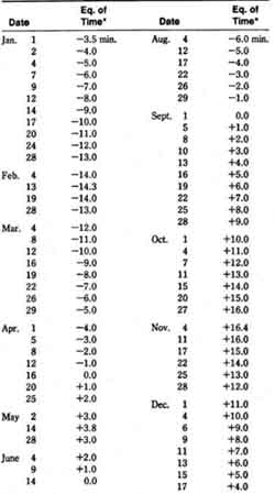
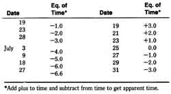
Adjust time of local apparent noon: Refer to the Date
Time Equation chart (Table 6-1) for correction of the time that the observed sun is ahead or behind of the “mean” sun. (The observed sun changes its angular rate of travel according to the seasons. For this reason, astronomers invented the “mean” sun which moves along the equator at a constant rate, 15 degrees per hour.)
Example:
Greenwich time of local noon: 17:24
date adjustment for August 29 minus 01 minute
equated Greenwich time of apparent noon: 17:23

Fig. 6-2 World Time Zone Chart.
• Determine position: Calculate the difference between Greenwich noon and the “equated” Greenwich time of local apparent noon:


Table 6-1. Date-Time Equation Chart for Longitude Determination
Example:
Greenwich time of apparent noon (equated): 17:23
Greenwich noon is: minus — 12:00
difference in time is: 5:23
• Calculate position: To establish how many degrees you are from Greenwich England you must only compute the following:
one hour equals 15 degrees of longitude four minutes equals 1 degree of longitude difference in time is 5 hours:
5 hours X 15 degrees equals: 75 degrees
23 mm divided by 4 equals: 5.75 minutes
added together equals: 80.75 degrees
Your position is 80 degrees 45 minutes west longitude. Note: Since there are 60 longitude “minutes” in a longitude “degree,” do not confuse navigation “minutes” with watch or clock minutes.
If you had to add hours to Greenwich time during your time zone correction then you are west of Greenwich. If you had subtracted hours, then you are east of Greenwich.
Note : If your watch has been set to daylight savings time, your conversion to GMT (Greenwich Mean Time) will be one hour less than from the time on the chart. (In the example above you would add only four hours, not five.).
PREV: Exposure: Hypothermia and
Dehydration
NEXT: Operational Survival Skills
All Sea Survival articles
© CRSociety.net
